Sunday 11 November 2012

Hilbre Island


Hillbre from Caldy Golf Course.
 
 
On friday I visited Hilbre Island with a birdwatching group that I have signed up for. Hilbre is a tidal island in the Dee Esturay off the top of the Wirral penisular. By coincidence I had played golf at the nearby Caldy Golf Club the previous weekend and hence the photo at the top.


Hilbre can be reached by foot at low tide from West Kirby and so on a cold morning we gathered at the slipway and set off to walk to the island. There are actually 3 island the tiny Little Eye, Little Hilbre and Hilbre Island itself.

We set off heading for Little Eye as this is the recommended route and after about three quarters of a mile we reached the first of the islands.

 
Little Eye is a very small island with no building and and we had  short rest here, while we waited for some latecomers to catch us up and while waiting we spotted a group of around 40 grey seals resting on a sandbar further out in the estuary.
 
 
Once the group had reformed we left little Eye to walk to Little Hilbre again and island with no buildings but with some interesting rock formations. The island are mostly sandstone and are eroded by the sea and winds, Little Hilbre had the best examples of these erosions.


Finally we continued on to reach Hilbre Island itself. Hilbre does have a few buildings both intact and ruined.
 
There are no permenant residents but there are a couple of privately owned houses, as well as buildings used by the group that monitor the islands. We crossed to the northern tip where there is a ruined lifeboat station and this proved a good place to observe the birds we had come to see. Amonst the species we saw here were Oystercatcher, Knot, Brent Geese, Turnstone and a lone Purple Sandpiper. The last 3 were all new birds to me.


We spent about a hour here and then, as one of the guys would checks on the birdlife of the island with us, we headed towards their observatory to eat our lunches. On the way we checked on one of the places where they trap birds so they can ring them and found a Chaffinch wihch was duely taken, ringed and then released.
 
We then had a little tour of other places on the island, there is quite a bit of history to be seen, including  the telegraph stationwhich was built in the mid 1800s by Mersey docks and is still standing.


We were also told how during WW2 Hilbre was the base for a string of decoy lights down the Dee estuary, which were supposed to confuse German bombers into thinking it was Liverpool Docks.
 
After a 4 hour visit to the islands we set off on the 2 mile walk back to West Kirby. It was a very enjoyable and interesting day and it might be nice to return on a nice summer day and stay on the island while the tide comes in and goes back out again.
.


Saturday 8 September 2012

railways and a stone henge


Today we headed down to Derbyshire to was a couple of trails on old railway lines. We started off a Parsley Hay cycle centre, this was originally Parsley Hay station on the Cromford and High Peak railway. The bed of the railway is now part of the High Peak Trail. The place was very busy and we set of southward toward a junction wshere the Tissington trail commences. We continued on the  narrower High Peak trail, which lead through a cutting full of trees and bushes alive with birds, pretty certain  I spotted a whitthroat and a chiff chaff here. The trail continued through a small tunne lunder the A515 main road. We passed through more cuttings and between farm land on a glorous September mornimh, the only downside being us having to move over to let cyclists past.

After a couple of miles we reached a brick factory at Friden Grange and shortly afterward left the trail to walk up a monor road and then cross the A515 again. A short distace from here we past the Newhaven House Hotel, now unused but originally built in about 1800 as a coaching inn which at its heyday had stabling for 100 horses. We now turned up the farm track leading to Stanedge Grange and we crossed the farm yard andwalked through a field where a view opened up of over Hartington and the hills in the distance over Manifold Dale.

After taking a break in a field to eat our lunch, we dropped down through fields to reach the Tissington Trail and headed north. This trail is somewhat wider than the High peak trail, I can only assume it was a double track railway as opposed to a single track we had been on before. Before long we reached Ruby Wood, which was palnted in 1991 to mark the 40th anniversary of the Peak District National Park and contains a good variety of native British trees.

We continued along and soon reach Hartington Signal Box this has been restored and still has the signal levers in situ, it is also a poular stop for cyclists and walkers so unusally on our walks we were able to buy ice creams. This railway line was originally part of the Manchester to London line.After the break we continued walking above farmland I spotted a groug of baby swallows perched o nthe top of a barn door waiting for their parents to return with food for them We also had good views down  through Hand Dale, where the road to Hartington runs. We then passed through the deep cutting though limestone, before reaching the junction again and finished the walkback at Parsley Hay.


Now, the prehistoric site of Arbor Low is only a mile away from Parsley Hay, so we jumped in the car and drove around to Upper Oldhams Farm on whose land Arbor Low stands, and after parking took the short walk up through the farm fields to Arbor low.


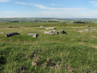
Arbor Low is a Noelithic Henge and consists of a band enclosing a ditch and then a raised area where 40 or so large  limestone  blocks are arranged in a circle, although unlike its more famous cousin in Wiltshire none of the blocks are now standing. It is suggested that it was constructed sometime before 2000BC and a barrow was added in the Bronze Age. A short distance away there is also the Barrow of Gib Hill, this was originally contrcted prior to Arbor Low but a second barrow was added in the Bronze age. After visting Gib Hill we returned to the car for the journey home.

Todays walk was around 8 miles in total but was for the most part pretty flat, but enjoyable neverthe less.

Tuesday 28 August 2012

Shutlingsloe


There is a hill that you can see arouind the Cat and Fidle area that lookd like a child's drawing of a hill, the is Shutlingsloe.
With my walking friend still on holiday due to working in a school, we decided to do a walk which included Shutlingsloe. We drove to the Macclesfield Forest to start this walk and parked in the carkpark in the forest. The start of the walk led uphill through the forest mostly conifers and I hoped to spot some birds like Goldcrest that are usually seen in coniferous woods, sadly I didn't see anything, but it would have been a bonus the point was to walk.
After a steep climb up through the forest we took the path heading towards the hill and down and now started walking through moorland. There were quite a few other people about and it was fortunate that a path of stone slabs had been laid, as the surrounding moorland was quite boggy.
After and easy walk, we soon reached the foot of the hill and started the final climb. This part is very steep and quite rocky but after a bit of a scramble we reached the top. The view from the top is quite somthing looking acorss the Cheshire plain as far as the Mersey Estuary and the North Wales hills in the far distance. The  Jodrell Back telescope is also in view.
After spending some time on the top we continued the walk by descending on the far side of the hill down sa slope as steep as the one we had climbed but without as good a path, We descended onto a farck track and followed this down towards Wildboarclough.
We walked along the road for a short while but noticed a wooden bridge across a busy stream which ran alongside the road, so took time out to take some photos.


We returned to the road and soon left it again to take a path around the bottom of Pleasant Meadow where the path took us through gorse bushes, before walking through fields which climbed to reach a path on the edge of the moorland. This led down towards Oakenclough and here we left the track ti walk up the side of the stream flowing through the clough, before a short steep climb took us on the the edge of High Moor. We crossed the corner of the moor before descending again down a very wet pat to emerge on a road at Hanging Gate Inn.
We now followed this road back towards the forest and detoured a little to walk through the woods before returning to the Carpark.
It was a lovely walk with some steep climbs which happily didn't task me as much as they did my friend, the 6 and a half miles took us 4 and a half hours but we did stop quite a lot.


Sunday 26 August 2012

In search of waterfalls part deux

Back in May we went to find a "hidden waterfall" Our quest ended in glorious failure as due to a dry spell all we found were dry rocks. Today we decided to have another go, so much rain that we were sure we would see the waterfall this time.
We set off from the same spot and climbed up along the line of Cote Ghyll, the weather was dry but dark clouds were threatening. The way was quick boggy when we reahed the top of the climb but we were encouraged by the sound of the beck bubbling in the valley below.
We went through a gate on the path onto the High Cote Moor and looking in thew distance we could see the line of the stream that we knew from the last visit was the stream that ran down to the waterfall, we walked along the path and then branched off towards the top of the Ghyll where we were rewarded by this.


We sat on the top of the ghyll and had a snack and then I scrambled down to the beck to get some more photos


The rain was threatening now and so we headed back to the car, unfortunately the rain came so by the time the time we got back we were absolutely soaked but it was well worth getting wet!
 
It is called a hidden waterfall and it is easy to see why, as we were approaching where we had to leave the path, we saw a group of walkers coming the other way  but did they detour to look, no they didn't and saw missed a hidden gem. We did bump into a chap walking up in the rain as we were descend the hill and asked where he was heading, he said just looking for a hidden waterfall, so we pointed out the way to him.
 

Friday 3 August 2012

Widdop and Gorple


For various reasons it has been quite a while since we went walking, but we finally got the boots back on and I suggested we head to Widdop and the moors between Burnley and Hebden Bridge, an area I used to visit at lot when younger.

We started at the dam wall of Widdop Reservoir and having crossed the dam, we followed the track along the water past many rocks that are popular with climbers and then started to climb the hill that led onto the moorland. My friend was getting out of breathe as we climbed the hill but again the benefit of playing a lot of golf showed as I didnt have such problems. We were forunate with the weather an it was very pleasnt although quite windy on the top. We walked over the moor and soon we could soon see over towards  Lancashireon the far  side and the Upper Gorple reservoir came into view as well.
We now left the main path to head downhill on a narrow muddy path past a couple of rocky outcrops and we soon reached the service road to the reservoir.

I was hoping to see some birdlife but so far I had seen nothing, but we followed the road towards the Lower Reservoir and passed a small wood where finally I could hear birds I spent a little time watching and listening and was rewarded by seen several as yet unidentifed birds including 3 chicks sitting in a line and branch while the parents flew backwards and forwards bringing them food. I got some nice photos and will hopefully indentify them.

We started to look for somewhere to take a break and a snack and ecided to leave the road and scrambled down a back and over a stream. While we were sat, I finally spotted a red grouse followed by a couple of others, I was pleased they were the first I have seen this year, sadly they vanished before I could get a photo.

The route we were following, would have had us follow the service road back to the main road, but as we didnt fancy walking the last 3/4 of a mile on tarmac, we decided to follow a footbath me had seen on the map that lead back to the rocks about Widdop reservoir, so as we walked along the side of Lower Gorple reservoir, we branched off the route along this path. It was obvious that the path was little walked as the grasses came up to out waists in places. It led through a wood that had been affected by a fire in the past, we could see a lot of burnt tree trunks. We continued to walk this path back across the the moor, fortunately there were posts to indicate the route of the path as it couldnt be seen very well.

Eventually the path emerged at the top of the hill above Widdop Reservoir and we followed the path down the face of the hill until we reached the path around the reservoir which led back to the car.

Stanton Moor 04/06/12


Stanton Moor is in the South Peaks and in an area of limestome stands out as a small island if gritstone.

We started this walk in the tiny market town of Winster, most noteable for a 17th Century Market Hall. The route took us out of the village and down into a valley and then we climbed through a small wood to reach farmland near Birchover. We walked past a busy campsite and then further upward to reach a small road. We wallked up the road for a 100 yds and then followed a path that lead up to Stanton moor. as moors go it is quite small and crossed with many paths. There are a lot of large rocks on the moor and many large Rhodedendrum bushes, also many tumuli, prehistoric burial chambers although they are cover ingrass and just appear as a small hump in the ground. At least 70 have been identified. We followed the path which skirted the moor and we soon had great views into the Derwent Valley and Darley Dale. There is a restored steam railway than runs through Darley Dale and we saw a  train in a station below us.
As the path turned around the eastern side of the Moor, we could see Earl Grey Tower which stands on the edge of the moor. This was built to commemorate the 1830 Reform act. We now moved away from the perimeter and soon arrived at the Nine Ladies a bronze age stone circle, the stones are all quite small and I had difficulty taking a photo that didn't show someone using one of the stones as a seat, this is a popular spot.


Our route now took us across the moor, and whilst stopping for a break we could clwarly hear a Cuckoo calling in a stand of trees behind us, sadly I was not able to catch a glimpse of the bird. I think it was the first time I have even heard a cuckoo. As I said, the moor is quite small and we soon reached the western edge, by a disused quary, one of many around the edges of the moor, another large rock known as the Cork Stone stands here.
We now followed the road towards the village of Birchover, before branching out onto a steep path which led down behind the village itself and emerged on another road opposite the Druid Inn.
Unusually for us, we decided to stop at the inn for a little refreshment. After a short break we continued down a track under Rowtor Rocks, an interestin group of rocks which we decided not to look at more closely, a shame really as they seem to have an interesting history.
We then followed the path which went around a farm and then down hill to eventually reach a road, which we decided to follow back to Winster.

Magpie Mine 27/05/12


We drove down to the pretty village on Ashford on the Water, on the river Wye. Once we found a parking space, we set off through to village crossing the river over the old bridge and crossed the busy A6.. After following the footpath a little way we branched off onto a minor road and soon cane to a path that led to the river.

We followed the river upstream heading towards an old derelict bobbin mill, as usual I kept my eyes open for birds but apart from a coule of Mallards did not recognise anything else. Although derelict the bobbin mill was quite interesting, only small but with two waterwheels. A little futher up the river was the weir presumeably built to divert water for the mill, the river above the weir is broad and still. A little further upstream and we came to a small lake, mallard and tufted duck on here plus a family of Coot, including several chicks.

We now left the river and began to climb up through a wood, lots of birdsong but nothing spotted, The path reached almost the top of the wood and then descended to reach the mouth of Deep Dale. We started to walk up the dale. As dales go it isn’t the most picturesque, a small stream meanders through it and there were lots of cowslips on the sides. Eventually we left the dale and climbed up the steepish side to reach farmland. We could now see Magpie mine across the fields and we headed towards the village of Sheldon, which was original home to the miners.

We followed a path from the village and after a short while we reached the mine. Magpie Mine is one of many lead mines in the area but is one of the few ,possible the only one, where a lot of the buildings and structures are still standing. It is surrounded by spoil heaps which have now been covered with grass and lead tolerant flowers such as leadwort.

Interestingly further investigation following the walk shows that the mine was in operation on and off right up tho the early 1950, so its not surprising that a lot of it remains.

On leaving the mine we set off to walk back to Sheldon and from there took paths that lead down past flower filled meadows to the River Wye and so back to Ashford.

It was a pleasant enough walk with a couple of quite strenuous but short climbs. The river Wye was lovely and the mine was interesting but we have certainly been on a lot nicer walks.

Sunday 6 May 2012

In search of Waterfalls


Time for the first walk of the year, delayed for various reasons. Having had a look around for a nice walk to start with I came a cross a long walk which mentioned a hidden waterfall. Although the full walk was beyond my walking friend and my own capabilities, a look at the map showed that a 5 miles ish there and back walk would take us up to this watefall. So off we set to Arncliffe in Littondale.

It was a nice drive, first towards Skipton, then up to Grassington past the impressive Kilnsey Crag and then up towards Arncliffe. When we arrived, the first problem was nowhere to park, a narrow road between limestone walls and no laybys. The only place was a camping site so I cheekily asked if I could park there, it was no problem, just a couple of pounds in the charity box, so we parked up and set off.

We didnt know the exact spot we were aiming for but we followed a bridal path heading up towards High Cote moor, a steep climb to start with as the path climbs just to the side of Cote Ghyll, a steep sided valley. I was on the lookout for wild life and was quite surprise to see a pair of Oystercatchers (not many oysters on the moors).

There were hardly any other people up here and it gloriously quiet as we continued upwards, there were several streams on the route up the hills and we kept our ears open for the sound of water, as the instruction was you will here the waterfall rather than see it. The only thing we could here were the sounds of birds and so continued upward. We reach High Cote Moor but no sound of a waterfall, one thing of note we did see was what looked like an arched mine entrance, now filled in, but three arches were visible indicating the downward slope of the mine entrance. A bit of googling when I got home however showed that in fact it was an old lime kiln

We decided to climb further and finally reached Top Lineseed, at this point we decided to call a halt to our outward journey, much further and we would have started descending towards Malham Tarn.
So, having had refreshments, we surveyed the landscape to try and work out where this well and truely hidden waterfall might be. We decided to walk along the top of the hill to see if there were any steep drops, there were several but not waterfalls. So we decided to start on our way back down and try to get nearer to Cote Ghyll, our last chance.

Finally we were rewarded, we could see the line of a stream descending and saw a ledge over a drop, just one problem, there was no water! We tried to imagine the water splashing over cascades and then tumbling over the ledge into a pool below but that was the best we could do. The photo at the top was what it should have looked like, this is what we was


Rather disappointed we made our way by to the main track and followed it  back down the hill to our starting point.

Despite not seeing the waterfall it was a lovely walk, quite strenuous for us, a climb of 900 feet on the 2.5 mile outward journey, but the return 2.5 miles were a pleasant downhill stroll. Apart from the Oystercatchers, there were several Meadow Pipits, and a  good number of Wheatear, a pretty little bird, several Curlew calling and flying overhead too.

Thursday 2 February 2012

Marshside


Today I went to Marshside RSPB reserve in Southport (or just outside) which is a great place to go to see waterfowl. There are 2 hides both overlooking loagoons and are very comfortable too.

The first hide  I called in gave very good close views of a good variety of duck, Mallard, Teal, Wigeon, Shovellers and Shelduck. looking past the lagood to the field beyond, there were Canada and Pink Footed Geese, Curlew and Black Tailed Godwits.


After spending quite a bit of time in this hide I moved along to the next, not quite as well appointed but again giving great views. Very much the same birds but also Pintails, quite a lot of gulls including the not so common, Common Gull, a large flock of Pink Footed Geese also flew in while I was watching and also the most suprising of all a pair of Black Swans, which all though there are quite a number wild in the UK are not yet listed as british birds.

I was intending to walk out onto the sands to see more waders but unfortunately I didnt have time today, still its a good excuse to return soon.

A few photos of the birds I saw today

A Group of Wigeon


Teal marching in line across the ice.


Pintail


Group of shoveller


Black Tailed Godwit


Black Swans


Thursday 26 January 2012

Moore - I saw an owl!

Having read a lot about Moore Nature Reserve near Warrington, I headed down there today, Its quite a big place by the side of the Manchester Ship Canal, with lagoons and woodland, so a chance to see a variety of birds.
Sadly, I am not very good at spotting and recognised birds I dont know and after a good hours walk I had hardly seen anything I could a name too. I finally arrived at a hide where 2 guys were sat. I had heard that there was a Tawny Owl that was regularly seen during the day and so I asked them if they knew where it was. One of them generously offered to show me as it was quite close to where we were, and sure enough there it was in the ivy on a tree trunk, just its head showing but clearly an owl. In all the years I have had an interest in birds I have never knowingly seen an owl in the wild so this was a big first for me and here he or she is.


I barely got round half the the reserve and am going to have to go back, hopefully with people who can spot and recognise birds.

Wednesday 25 January 2012

Dunham Massey

Well after a few days stuck indoors due to the weather, I finally got out today and set off for Dunham Massey near Altrincham. it is a house, gardens and park managed by the National Trust and a place I have visited before. I was particularly looking for birds today and so I spent my time in the gardens and the park. The gardens are quite colourful even in january with snowdrops, crocus and daffodils on show, I spent most of the time scanning the trees, there were plenty of tits and nothing new until I spotted movement on one of the tree trunks, it was a Nuthatch, I have only ever seen one before so it was a nice spot, they are quite pretty being bluey grey on top and buff underneath and behave a lot like treecreepers. I tried to get a good photo but it promptly ran rounf the otherside of the trunk, but I did manage this.


I then had a wander around the park, there is a deer sanctuary and using binoculars I did see a small group of Roe Deer through the trees.

That was about it for interesting spots although there were plenty of Great and Longtailed tits, Jackdaw, tufted duck as well as the far more common birds.

Thursday 19 January 2012

Twitching

Since I have retired, I have taken to going out for  a bit of fresh air and exercise but going to places where I can expect to see birds. I thought I would these trips to my blog.
The weather has been excellent these last few days so here is a catch up on where I have been.

Thursday, I went for a walk around Worsley Woods, these are situated between the M60 and the A572 Worsley Rd. They start at The Delph, which is a pool where the old underground canals from the coal mines emerge to join the Bridgewater Canal. I had heard a Kingfisher is often seen here so I set off with high hopes of seeing on, although on a previous visit here I had failed. I had a good look in the Delph when I arrived but my quarry proved to be elusive and so I set off up the path into the woods themselves. After all the rain the paths were very muddy, but there were very few people around so it boded well. Parts of the wood are quite marshy and there is also a small man-made lake called old Warke Dam. I looked at every sign of movement but more often than not it was a Grey Squirrel, there must be hundreds here, although one movement did turn out to be a treecreeper, a first for me.
In the woods there were lots of birds. Great, Blue, Coal and Longtailed tits, Chaffinch, Jay, Crows,Magpies and a flock of around 50 Woodpidgeons.
As I got to the lake, I saw Mallard, Mute Swans, Teal and in the trees overlooking the lake 6 Grey Heron. There is an impressive house in the woods and the lake was built and stocked with fish, but apparrently isn't fished now except by the herons.
On the way back to the car I stopped again at the Delph and this timw I rewarded, the Kingfisher was perched on the branch of a dead tree in the pool, and I got a few pictures before returning to the car and home.

Friday

I decided to go to Dovestone Reservoir, near Oldham, the area managed by the RSPB so I was hopeful of some nice sightings but when I arrived the place was full of dog walkers and people with small children, it was very noisy, even the bird feeding station was full of feral pigeons so after a short walk to take a couple of photos, I drove a little  way up the road to a place call Binn Green, which over looks the reservoir. Here there was another feeding station but it was much quieter so I had a wander around and saw a good number of birds, all the usual tits there were at Worsley but also a lot of Goldfinches plus Greenfinch, Siskin and Lesser Redpoll, the last two being firsts.

Sunday

I ventured farther afield and drove up to the Leighton Moss RSPB reserve with the hope of seeing a family of Otters. Having found out where they were likely to been seen I set off for one of the hides, most of the water was frozen but there were patches with plenty of birds, I enquired about the otters and yes they had been out all morning but despite a long wait they didnt not re appear  for me, however I did see several Bittern including one flying over, they stand in the reeds and blend in so well that it is diffult to spot them but no mistaking them in flight. Also I saw Marsh Harriers and Sparrowhawks covering the site looking for prey, there were also a couple of Snipe on the edges of the lagoon, also a Water Rail, another shy bird. On the water there were Teal, Tufted Duck, Shelduck, Gadwall (a first) and Cormorants, I then waited as it was approaching dusk for the starlings to flock, While waiting I saw a Glossy Ibis and several Little Egrets flying in to roost, both firsts for me. (someone pointed both these out to me). Then the starlings started to arrive, you could see flocks building up in the distant and merging together as they approached the reeds were they roost, there must have been thousands as the seemed to perform for the viewers flying right by the hide several times. A starling on its own is no big deal but seein g so many together is quite stunning, still photographs cant do them justice.

Monday

Off to Pennington Flash, a popular site for me being only 20 minutes away. The site is on what are flooded mine workings with a large lake ples small lagoons and reeds and also woodland all in quite a small area. In the big lake there were a lot of gulls, Black Headed, Great and lesser blackbacked and Herring, a bout a dozen Cormorants, loads of Mallard, Canada Geese Coots and MuteSwans after scraps visitors throw for them. I walked around the smaller lagoons again most were frozen but did see Tufted Duck, Gadwall again and Shelduck.
I then headed for my favourite place, a hide overlooking a feeding area, on the way there I was walking along a path the runs next to a golf course, when  I saw a flash of blue flying up the stream between the Flash and the golf course, another Kingfisher! The feeding area is  always popular with tits and finches I saw a lovely Bullfinch, plud a Reed Bunting ( a first), Moorhen, Dunnock, Pheasant, and Squirrels. I then returned to the big lake as the sun was setting to get a few sunset photos, also saw a Grey Lag  Goose.
On the way home I pulled into a layby to take some photos of the Headgear at the old Astley green Colliery.

Tuesday

Today I was very close to home on the bank of the River Irwell in Salford, suprisingly, it was a quiet area near Agecroft Bridge and on the walk I saw some nice waterfowl, especially Goldeneye and Gossanders (a first) I also spotted a pair of Green Sandpipers (a first) as they were disturbed several times and fly up and down the river.

So a lovely few days, several new spots and a total of 52 species of birds.