Wednesday 9 July 2014

Blackstone Edge and The Tour de France


Ever since I found out that the Tour de France was starting in Yorkshire this year, I wanted to go and see it live. Not because I was mad about cycling, I hadn't been on a bike for many years but it is a massive world famous event and it seemed a shame to not see it considering how near to home it would be passing.

The problem was where to go to see it, without getting there ridiculously early or not being able to see because of the crowds. When I checked the route I found it would be passing Blackstone Edge Reservoir on the hills above Littleborough, near Rochdale. Looking at a map, I realised that Blackstone Edge was on the Pennine Way, which passes close to the Ripponden turn off on theM62 and only 3-4 miles from Blackstone Reservoir, so it seemed like a good idea to incorporate a nice walk with seeing the Tour.

An early start saw me drive to a parking spot had found near the M62, when I arrived it was apparent that many others had had the same idea. Fortunately I found a parking space and set off with the masses to walk over up to Blackstone Edge. The path was full of others, I doubt if the Pennne Way has had so many people on it at one time in its entire history.


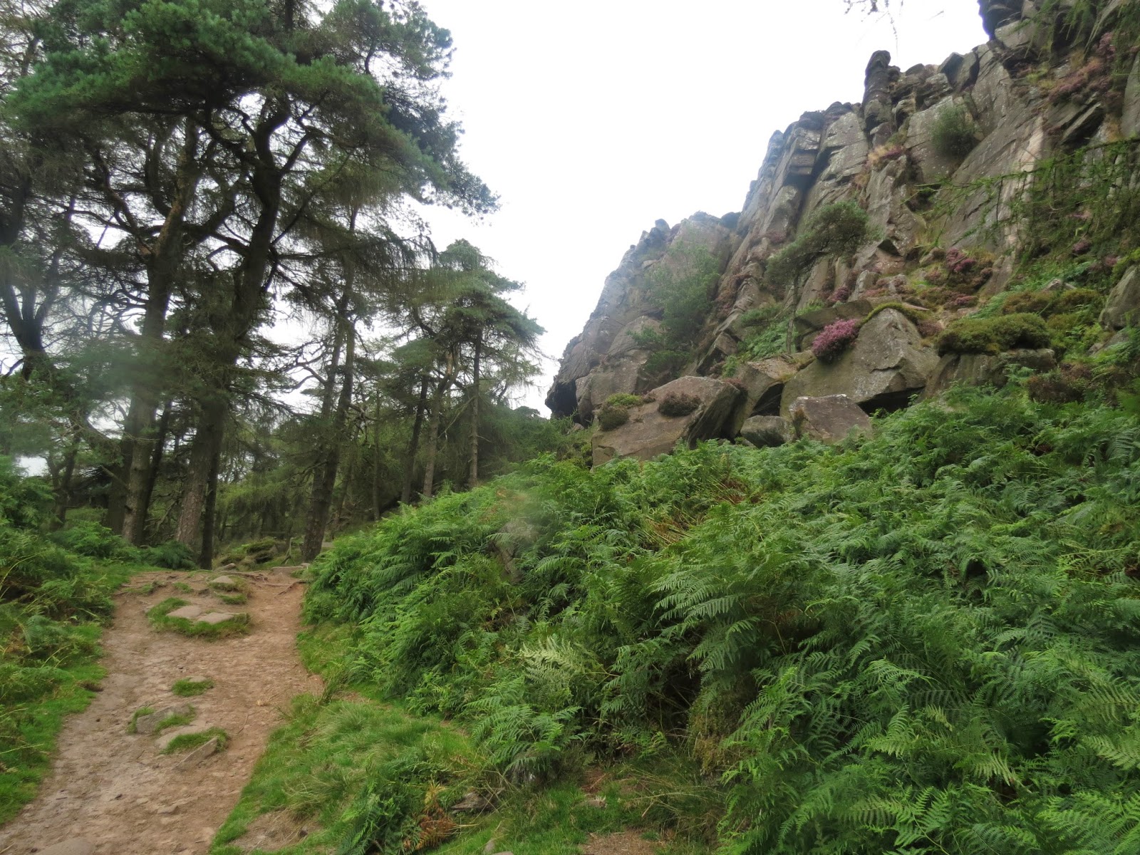
The walk was relatively easy going as the path ascends up to the Edge itself and while it s not as dramatic as some of the ones we have walked n the Peak Distrct it certainly gave great views, from the Peak District, over Manchester and round to Winter Hill and even Pendle.


Once the path reached the top of the edge it dropped until it reached a “roman road”/old packhorse road and at this juncton stands the Aiggin Stone, a 4 foot medieval waymarker that had stood for around 700 years. At this point it was hard to follow the trail and everyone seemed to pick ther own route down towards the reservoir. Once the reservoir came into view, we could see the masses of people making their way up from Littleborough as well as hundreds who had arrived already.


It was impossible to get close to the road the race would take and so we found a nice hillock a hundred yard back which offered a good view of part of the road across the reservoir. Although it was still over 2 hours until the riders passed there was plenty going on, with processions of cars, motorbikes and sponsors vehicles which made a long cavalcade that preceded the cyclists themselves. As the point where we were waiting was just after a long climb, we were unable to see anything until the riders would actually appear but everyone knew that helicopters followed the riders and so everytime a helicopter appeared expectation rose, only to subside, when the riders did not appear.

Finally we heard cheers and suddenly the leadng group appeared surrounded by a group of cars and motorbikes making the few cyclists hard to spot and soon they were round the corner and going away from us


. Three minutes late the main peleton appeared, all closely bunched together, and travelling qute slowly giving everyone a good view before they too rounded the sharp corner and vanished from sight.


This was the signal for a mass exodus, which we joined and followed a long procession back over Blackstone edge and back to the car.

The weather was lovely and it was a really good day, and although it only took a few minutes before the first and last riders passing by it was a great experience and I am really glad that I made the effort to witness it.

Monday 30 June 2014

Its been a while -The Roaches and Lud's Church

                                                                     The Roaches

I have rather neglected this blog, not because I have not been walking, I have, when golf have not got in the way, but I never seem to get around to updating it.

Since the last entry about a year ago, we have done some really nice walks. We finally walked the real Froggatt Edge, this was a walk we did a couple of years ago but by mistake we walked White Edge instead. How we could have confused the two s a mystery to me as they really are completely different.

We have walked round Mow Cop, a village on the Staffordshire Cheshire border, Darwen Moor, n Lancashire and Waddington Fell in the Forest of Bowland, We have walked from Bakewell to Chatsworth House and back and  Formby beach and woods, as well as also several canal walks as my walking partner as found an interest in canal travel. They were all  lovely walks however the best and most surprising of the walks was over the Roaches and through Lud's Church in Staffordshire at the Southern end of the Peak District.

Mow Cop, not a run but a folly but in the 18th century
                                                           The Old man of Mow

                                                    Ingleborough from Waddington Fell

 
                                                            Red Squirrel at Formby
 
        
We had a little trouble finding the Roaches, mainly due to me entering the wrong post code in the sat nav. We did finally get on the correct road and we drove a few miles out of  Leek when we were surprised to see the rocky hill of Hen Cloud appear in front of us. I say surprising as we were driving through faierly gently countryside and to see a large rocky clad hill was quite unexpected.

                                                                   Hen Cloud

The Roaches are a series of rocky ridges that run from Hen Cloud, which itself stands apart from the Roaches and its rock faces are popular with climbers .

We parked on the road side, and set of on our walk. The track took us between Hen Cloud and and Roaches and we were soon walking uphill as we neared the first of the climbing sites. The route took us along the bottom of some of the climbs before we picked our way up and onto the top of the ridge.

These ridges command some great views, from the Malverns in the far south to Winter Hill ,and from the Welsh hills over to various heights of the Peak district.

We walked along the top of the ridge and came to Doxey Pool, a small pool on the very top of the ridge. The Roaches used to be home to a small colony of Wallabies, that were released into the wild during the 2nd World War. Sadly there are no reports of any being seen over the last 15 or so years although they did successfully bread here for a number of years.

We continued from Doxey Pool and when we reach the point where we had to descend, we stopped for our lunch. After a break we descended form the ridge and then followed a path down until we reached a wooded area and we set off to find Lud's Church.

After a nice walk through sunlit woods we fnally arrived at Lud's Church, this is not a real church, but is infact a deep cleft in the rocks and owes its name to the fact that it was used as a secret place of worship by the Lollards n the 15th Century. It also has legends surrounding it claiming the likes of Robin Hood and Bonnie Prince Charlie used it as a hiding place to escape capture.

The entrance to the church is almost a pothole, a small hole n the ground where you scramble down to reach the floor and find yourself n a narrow passage with lichen covered rock faces rising around 50 feet above you. It is certainly an atmospheric place and well worth a visit.


                                                          The entrance to Lud's Church

                                                                    Lud's Church

We walked the length of the "church" around 100 yds before continuing on to the far end of our route, we were now out of the wood and back onto a sandy path. This is where we first encountered the flying ants and there were thousands of them, the path was just covered and they filled the air as were started out homeward leg of the walk. This part of the walk was along a low ridge covered in heather.


We eventually reached the path we had taken when descending from the Roaches and instead of climbing back onto the ridge we followed a road that ran at the base of the rocks and after a couple of miles we arrived back at our starting point.

Sunday 2 June 2013

The Dales of River Wye.


Today we decided to return to the River Wye and walk some more of its dales. We set off to Monsal Head to start the walk. Monsal Head stands on hills overlooking a bend in the river  and also looks down on the old railway viaduct which now carries part of the Monsal Trail.


We descended from the Head down a woody path towards Monsal Weir and here we crossed the river and started to follow it downstream through Monsal Vale It was a lovely sunny day although there was quite a breeze which kept things nice and cool for walking. The path followed the river, sometimes leaving it for a while but always returning to it again, there were lots of wild flowers in bloom, needless to say I don't really know what they were except the bluebells, I really must buy a book. We even stumbled on a tiny overgrown water wheel.


After a pleasant walk we then left the river and crossed the busy A6 at White Lodge and started a long climb up towards Taddington village. The route followed a rocky path up a valley called Dimin Dale before emerging at the top into farmland and we then followed a farm drive into the village. We approached Taddington from the opposite end from last week and no soon had we reached the village we turned away from it to walk back down to meet the A6 again.

We crossed the road again and followed a bridle way which led us to High Dale. This is a narrow V shape Dale and at around halfway through the walk we stopped to eat lunch. We walked through High  Dale until we took a path up the side of the dale and after crossing farmland we  found ourselves high above the Wye where it runs through Miller's Dale. The view from here was quite magnificent not only could we look down into the Dale where we could see steep limestone cliffs but also  towards the horizon and the hills of the northern part of the Peaks.


We descended into the dale and having crossed the Monsal Trail we paused on a bridge crossing the river, where the water was so clear we could see trout in the river, we could even see them rising to catch food.


 We then walked into the yard of the once infamous Litton Mill, which was notorious in the 19th century for abusing child labourers.

Leaving the mill behind up we continued along the banks of the Wye again, stopping to watch the birdlife on the water, some Moorhens were behaving very strangely I can only assuming it was part of the mating ritual. We saw several Dippers, one of my favourite birds, also a family of swans with very small cygnets.


We continued though the steep limestone sided valley and entered the quaintly named Water-cum-Jolly Dale as we neared Cressbrook.


 Here the river widens considerable by a large granite wall known as the Rubicon Wall where we briefly stopped to watch a rock climber negotiate a large overhang.


We then crossed the river over a fast running weir and started to climb the side of the dale
overlooking Cressbrook Mill. Cressbrook Mill is quite a grand building complete with a cupola on top. Like Litton Mill, Cressbrook has now been converted into apartments and would certainly be lovely place to live.


The path left the river and took us up to the Monsal Trail. The Monsal Trail follows the bed of a now closed railway and runs for about 8.5 miles from near Bakewell to Topley Pike 3 miles from Buxton, it travels through several tunnels. We followed the trail from Cressbrook tunnel over the Monsal Dale Viaduct, before leaving it just before the Headstone Tunnel, below Monsal Head.


We then ascended the valley to arrive back at our starting point.

This was on of the nicest and most diverse walks we have done, and at 7 miles also one of the longest, but as usual we took our time and were out for 5 and a half hours


Sunday 26 May 2013

First walk of the year


Well, its been quite a while since I added to this blog, what with golf and the cold spring, we haven't been out and about However, today was a great opportunity to get he boots back on and stretch the legs. Most of our walks follow routes in a book of Peak District walks. These are split into easy, medium and hard, we tend to stick to the easy and medium and today's walk was the last of the easy ones we had to do.

The walk started at Chelmorton, a village south of Buxton ans was to take in the villages of Taddington and Flagg, before returning to Chelmorton.

We parked on the road between the church and the pub and started walking up a steep path by the side of Chelmorton Low the hill that overlooks the village, this hill is not accessible but contains on its summit a couple of round prehistoric barrows, our route took us up what is known as a lead rake and is presumeable an area from which lead ore was extracted. Certainly, we walked through and area full of hump and hollows, which we have learnt to associate with the remains of lead mining.
As we reached the to of the rake we came to a bridle path and made a detour to see the Five Wells Chambered Tomb. this is a Megalithic Tomb reputed to be the highest in England. To be honest, there wasn't much to see, just a few stones, which apparently are one of the only chambers left standing, although in the past archaeologists had uncover 12 skeletons. It was rather sad that there was nothing saying what the site was, there was not even a sign identifying it.

We retraced our steps back to the route we were on, and continued to walk through farm land, to be honest it was a rather uninspiring. Although we did see plenty of  Sky Larks, Meadow Pipits and a Wheatear, there were also lots of Swallows, at least they think summer is on its way.

Soon we reached the summit of Sough Top and looked down onto the Village of Taddington, pictured at the top.. Before starting down the hill we stopped to eat our lunch and spent a while looking over the hills and valleys to the east of us, attempting to identify the various dales we could make out. I also spotted a very impressive Church in the distance but could not work out where it was, it certainly dominated the village it was in and  could well have been at Tideswell where the parish church is known as the Cathedral  of the Peak.

After our break, we descended into Taddington, rather unfairly described in our book as a bleak one street village. We did not linger and started to climb out of the village up the road to Flagg, I do not really like walking on roads and prefer fields and fortunately once we were out of the village we left the road to head across fields towards Flagg. Flagg is a tiny village with a street, a tiny church and school and a nice tea room, where, after watching a very large herd of cows being taken in for milking, we stopped to enjoy a cream tea.

We then commenced the final part of the walk back to Chelmorton, sadly the directions in the book were not very good and we could not follow them, however we did spot a bridle path that seemed to be going in the general direction, so we followed it and found ourselves back at the top of the lead rake we had walked up at the start of the walk. Although this wasn't where we were supposed to be we followed it back down to the village and the car.

All in all it was a pleasant walk and it was nice to be out in the Peak District again, but we have done lots of far more interesting walks.

Sunday 11 November 2012

Hilbre Island


Hillbre from Caldy Golf Course.
 
 
On friday I visited Hilbre Island with a birdwatching group that I have signed up for. Hilbre is a tidal island in the Dee Esturay off the top of the Wirral penisular. By coincidence I had played golf at the nearby Caldy Golf Club the previous weekend and hence the photo at the top.


Hilbre can be reached by foot at low tide from West Kirby and so on a cold morning we gathered at the slipway and set off to walk to the island. There are actually 3 island the tiny Little Eye, Little Hilbre and Hilbre Island itself.

We set off heading for Little Eye as this is the recommended route and after about three quarters of a mile we reached the first of the islands.

 
Little Eye is a very small island with no building and and we had  short rest here, while we waited for some latecomers to catch us up and while waiting we spotted a group of around 40 grey seals resting on a sandbar further out in the estuary.
 
 
Once the group had reformed we left little Eye to walk to Little Hilbre again and island with no buildings but with some interesting rock formations. The island are mostly sandstone and are eroded by the sea and winds, Little Hilbre had the best examples of these erosions.


Finally we continued on to reach Hilbre Island itself. Hilbre does have a few buildings both intact and ruined.
 
There are no permenant residents but there are a couple of privately owned houses, as well as buildings used by the group that monitor the islands. We crossed to the northern tip where there is a ruined lifeboat station and this proved a good place to observe the birds we had come to see. Amonst the species we saw here were Oystercatcher, Knot, Brent Geese, Turnstone and a lone Purple Sandpiper. The last 3 were all new birds to me.


We spent about a hour here and then, as one of the guys would checks on the birdlife of the island with us, we headed towards their observatory to eat our lunches. On the way we checked on one of the places where they trap birds so they can ring them and found a Chaffinch wihch was duely taken, ringed and then released.
 
We then had a little tour of other places on the island, there is quite a bit of history to be seen, including  the telegraph stationwhich was built in the mid 1800s by Mersey docks and is still standing.


We were also told how during WW2 Hilbre was the base for a string of decoy lights down the Dee estuary, which were supposed to confuse German bombers into thinking it was Liverpool Docks.
 
After a 4 hour visit to the islands we set off on the 2 mile walk back to West Kirby. It was a very enjoyable and interesting day and it might be nice to return on a nice summer day and stay on the island while the tide comes in and goes back out again.
.


Saturday 8 September 2012

railways and a stone henge


Today we headed down to Derbyshire to was a couple of trails on old railway lines. We started off a Parsley Hay cycle centre, this was originally Parsley Hay station on the Cromford and High Peak railway. The bed of the railway is now part of the High Peak Trail. The place was very busy and we set of southward toward a junction wshere the Tissington trail commences. We continued on the  narrower High Peak trail, which lead through a cutting full of trees and bushes alive with birds, pretty certain  I spotted a whitthroat and a chiff chaff here. The trail continued through a small tunne lunder the A515 main road. We passed through more cuttings and between farm land on a glorous September mornimh, the only downside being us having to move over to let cyclists past.

After a couple of miles we reached a brick factory at Friden Grange and shortly afterward left the trail to walk up a monor road and then cross the A515 again. A short distace from here we past the Newhaven House Hotel, now unused but originally built in about 1800 as a coaching inn which at its heyday had stabling for 100 horses. We now turned up the farm track leading to Stanedge Grange and we crossed the farm yard andwalked through a field where a view opened up of over Hartington and the hills in the distance over Manifold Dale.

After taking a break in a field to eat our lunch, we dropped down through fields to reach the Tissington Trail and headed north. This trail is somewhat wider than the High peak trail, I can only assume it was a double track railway as opposed to a single track we had been on before. Before long we reached Ruby Wood, which was palnted in 1991 to mark the 40th anniversary of the Peak District National Park and contains a good variety of native British trees.

We continued along and soon reach Hartington Signal Box this has been restored and still has the signal levers in situ, it is also a poular stop for cyclists and walkers so unusally on our walks we were able to buy ice creams. This railway line was originally part of the Manchester to London line.After the break we continued walking above farmland I spotted a groug of baby swallows perched o nthe top of a barn door waiting for their parents to return with food for them We also had good views down  through Hand Dale, where the road to Hartington runs. We then passed through the deep cutting though limestone, before reaching the junction again and finished the walkback at Parsley Hay.


Now, the prehistoric site of Arbor Low is only a mile away from Parsley Hay, so we jumped in the car and drove around to Upper Oldhams Farm on whose land Arbor Low stands, and after parking took the short walk up through the farm fields to Arbor low.


Arbor Low is a Noelithic Henge and consists of a band enclosing a ditch and then a raised area where 40 or so large  limestone  blocks are arranged in a circle, although unlike its more famous cousin in Wiltshire none of the blocks are now standing. It is suggested that it was constructed sometime before 2000BC and a barrow was added in the Bronze Age. A short distance away there is also the Barrow of Gib Hill, this was originally contrcted prior to Arbor Low but a second barrow was added in the Bronze age. After visting Gib Hill we returned to the car for the journey home.

Todays walk was around 8 miles in total but was for the most part pretty flat, but enjoyable neverthe less.

Tuesday 28 August 2012

Shutlingsloe


There is a hill that you can see arouind the Cat and Fidle area that lookd like a child's drawing of a hill, the is Shutlingsloe.
With my walking friend still on holiday due to working in a school, we decided to do a walk which included Shutlingsloe. We drove to the Macclesfield Forest to start this walk and parked in the carkpark in the forest. The start of the walk led uphill through the forest mostly conifers and I hoped to spot some birds like Goldcrest that are usually seen in coniferous woods, sadly I didn't see anything, but it would have been a bonus the point was to walk.
After a steep climb up through the forest we took the path heading towards the hill and down and now started walking through moorland. There were quite a few other people about and it was fortunate that a path of stone slabs had been laid, as the surrounding moorland was quite boggy.
After and easy walk, we soon reached the foot of the hill and started the final climb. This part is very steep and quite rocky but after a bit of a scramble we reached the top. The view from the top is quite somthing looking acorss the Cheshire plain as far as the Mersey Estuary and the North Wales hills in the far distance. The  Jodrell Back telescope is also in view.
After spending some time on the top we continued the walk by descending on the far side of the hill down sa slope as steep as the one we had climbed but without as good a path, We descended onto a farck track and followed this down towards Wildboarclough.
We walked along the road for a short while but noticed a wooden bridge across a busy stream which ran alongside the road, so took time out to take some photos.


We returned to the road and soon left it again to take a path around the bottom of Pleasant Meadow where the path took us through gorse bushes, before walking through fields which climbed to reach a path on the edge of the moorland. This led down towards Oakenclough and here we left the track ti walk up the side of the stream flowing through the clough, before a short steep climb took us on the the edge of High Moor. We crossed the corner of the moor before descending again down a very wet pat to emerge on a road at Hanging Gate Inn.
We now followed this road back towards the forest and detoured a little to walk through the woods before returning to the Carpark.
It was a lovely walk with some steep climbs which happily didn't task me as much as they did my friend, the 6 and a half miles took us 4 and a half hours but we did stop quite a lot.